
Day 1 - Rescue Day
(St Bees to somewhere near Nanny Catch Beck)
Two trains and 5.5 hours later, my train draws to a stop at St Bees. It is 15:37pm and I had to get a move on with 14 miles to cover in a projected walk time of 5 hours. My first destination was Low Cock How Farm and I wanted to arrive at the campsite before nightfall.
It was straight forward navigation for the first four hours. I followed signs and railway tracks. I hiked through farmland, passing through two sleepy villages, Moor Row and Cleator and I battled with the weight of my rucksack up Dent Hill (352M).


The sky was turning a inky blue, a sure sign that I had to move rapidly. Upon descending Dent Hill, I bumped into another solo walker, Anwar. We conversed about the coast to coast walk, and found commonality in that we'd both been to Morocco. "I can't believe you are doing this alone, that's terrific!" he said. As we were about to part ways, Anwar offered me his number and told me not to hesitate in contacting him if I got lost or ran into any trouble. It was an incredibly kind gesture. It didn't cross my mind at all that the need for help would arise just hours later.
I strolled quickly, disregarding navigation completely as I spotted a sign saying "Nannycatch Gate - 1 mile". I followed the rocky path straight into a far reaching field dotted with sheep, patches of long grass and a long stony wall running along the side. I walked for twenty minutes, until it occurred to me that I was completely off path. 'It's ok, I must be nearby...3 map squares away - 3km.
My optimism gradually turned to frustration, then to worry as darkness settled. I pull out my head-torch. I've walked mindlessly into a hilly field for 40 minutes and I am completely lost.

I take a rough compass bearing, which leads me straight to a stone wall. My morale dipped, the air pricked with coldness and my rucksack dug painfully into my shoulders and hips. I need help... I thought. After 20 minutes of further wandering and attempted navigation, I tentatively pull out my phone and text Anwar.
I retrace my footsteps, moving with hope towards a parked car light in the distance. Upon reaching the carpark, I realise that Anwar drove here from his home to find me. I'm embarassed and overwhelmed by his incredible goodwill.
We navigate together to Low Cock How Farm, and arrive to a farm-house locked and devoid of any activity. The house glows eerily in utter silence. We whisper: "it's definitely here. It's silent. It's 10:30pm at night. I would feel awful disturbing them at this time of night. Can I just pitch up in the car park? Concrete is too hard. Can I go into the field? I don't want to intrude without permission...
Anwar suggests that I can stay at his house for the night. My initial reaction is to turn down the offer, I promised my sister no more recklessness.
God, I've got nowhere to go, I thought. A whisper of cold air drifts through the air teasingly. Intuitively, I decide to go back with Anwar, drained and exhausted after a long first day.

I spend the night asleep on the sofa. I feel relieved, grateful, and reinvigorated for Day 2 for my coast to coast walk. I found it difficult to comprehend the genuine compassion and kindness Anwar showed me. He went above and beyond to help me when I was no more then a stranger to him. I felt words alone were not enough to express my gratitude. I am still utterly thankful to this day. Who knows what would have happened on my first day without Anwar's help. With my stubborn resolve, I would've probably walked into the night, hiking in the cold and possibly wild-camped on private land.
With a dull throb in my shoulders to contend with, I spent the morning relaxing. I watched '127 Hours' until Anwar returned from work (chemical engineer!) at lunchtime. He brought me a sandwich and dropped me off at the beginning of Leg 2 - Ennerdale Bridge. I thank him over and over and we exchange contact details. He wished me luck for the remaining hike, as I set off renewed with quiet optimism.


I reach the end of the forest by 6:00pm, approaching a small builder's hut. "How long will it take me to get to Mine Slade?" I ask. "You look young and healthy, just an hour for you, straight over the hill, follow the stream over", the builder replies.
The grass is wet and boggy. What stream? I wonder. Multiple thin trails of water trickle down the hillside. I squelch through the long grass, taking each step selectively. The ground is saturated, I sink a little with each step I take.
I begin the steep ascent , navigating my way through small plants and brambles. My heart jolts: the weight of my rucksack (13kg) nearly made me topple backwards. I keep my centre of gravity low, bent knees and hands near the ground. I really struggle. God, I'm slow. The ascent is relentless. I shuffle forwards, stopping every few minutes to catch my breath.
I'm exhausted by the time I reach the top. This doesn't look right. I climb over a wire gate. Okay, this definitely isn't right. I pull out the map and look for landmarks: 2 tarns near the coast to coast route and a quarry. Find the quarry, I think desperately. It's 7:30pm.
The wind howls, buffeting my movement, making my knees buckle. A mist begins to descend, obscuring my vision, I can only see 10M in front of me. My boot sinks straight into muddy, wet grassland. I am disorientated, I need to stop. Where? This whole area is unsheltered and open to the elements. It's too wet and marshy. You can't walk in the dark at 400m up. Stopping is safer then walking.
I find a patch of ground below a mass of rocks and pull out my tent. My shelter flutters wildly, threatening to tug away from my grip. I peg the tent down but the ground is too soft and it doesn't anchor my tent down firmly. I immediately crawl in. It's ok, you're inside the tent now, it won't blow away.
I woke early after a few hours of sleep and opened my tent to this view:
I zip my tent closed in fear and sit crossed-legged, nibbling on breakfast biscuits. My mouth is sandpaper dry. I'll wait for the mist to passover. I wait ten minutes, sheltered within the green walls of my tent. Don't be so naive, the mist could be here all day. You need water. I get up reluctantly and struggle packing my tent up in high wind. I throw my rucksack onto my back. It is no longer heavy, just a dull and thudding ache that would occur now and then.
I follow a compass bearing for thirty minutes until I reach the quarry.

Oh god, I really, really don't want to do this today. The walk was near the Helvellyn (950M) range, an area of the Lake District I walked extensively with Nathan in April. I knew the area was relentlessly steep, wild and mountainous. I made my decision when I reached Seatoller a few hours later: I decided to bus it and tour the area for the sake of my morale.
I purchased a Stagecoach 'explorer' bus ticket for £10.40 and I spent the day touring Keswick, Penrith then Patterdale.


I brought water purification tablets from Boots (£7.00). I never wanted to be thirsty ever again, it was an awful, desperate feeling that I didn't want a repeat of. I reached my old haunt, Patterdale Youth Hostel, in the late afternoon. Never have I appreciated a bed and a roof over my head so much. I spent the evening cooking up noodles for dinner and washing my clothes. My head spun with exhaustion, I had very little sleep the night before. It was 8:30pm: hair washed, clothes washed and fed. My head touched the pillow and I was out like a light.
I retrace my footsteps, moving with hope towards a parked car light in the distance. Upon reaching the carpark, I realise that Anwar drove here from his home to find me. I'm embarassed and overwhelmed by his incredible goodwill.
We navigate together to Low Cock How Farm, and arrive to a farm-house locked and devoid of any activity. The house glows eerily in utter silence. We whisper: "it's definitely here. It's silent. It's 10:30pm at night. I would feel awful disturbing them at this time of night. Can I just pitch up in the car park? Concrete is too hard. Can I go into the field? I don't want to intrude without permission...
Anwar suggests that I can stay at his house for the night. My initial reaction is to turn down the offer, I promised my sister no more recklessness.
God, I've got nowhere to go, I thought. A whisper of cold air drifts through the air teasingly. Intuitively, I decide to go back with Anwar, drained and exhausted after a long first day.

Day 2 - The Terrible, Awful, Most Atrocious Day Ever
(Ennerdale Bridge to the mountain above Black Sail Hut)
With a dull throb in my shoulders to contend with, I spent the morning relaxing. I watched '127 Hours' until Anwar returned from work (chemical engineer!) at lunchtime. He brought me a sandwich and dropped me off at the beginning of Leg 2 - Ennerdale Bridge. I thank him over and over and we exchange contact details. He wished me luck for the remaining hike, as I set off renewed with quiet optimism.
 |
| Eating handfuls of wild blackberries |
 |
| Walking along the bank of the Ennerdale Water |
 |
| Climbing up with my rucksack along the reservoir |


There was so much open, positive body language as I walked. The nods, smiles, 'hellos' and acknowledgements. My eyes meet briefly with a refuge driver, he gives me the thumbs up and points me in the right direction as I ponder over two different directions. Wow, people here are so friendly. I walked along the still and beautiful Ennerdale water, scrambling up rocky outcrops and ducking under trees.
It is late afternoon as I stroll through a secluded forest. The crunch of my boots along the trail. The clink of my water bottle. I stop and observe silence. Yet, there is no silence. There is the music of water trickling through rocks. The gentle ruffle of trees and the sway of plant life. I am alone and there is serenity.


I reach the end of the forest by 6:00pm, approaching a small builder's hut. "How long will it take me to get to Mine Slade?" I ask. "You look young and healthy, just an hour for you, straight over the hill, follow the stream over", the builder replies.
The grass is wet and boggy. What stream? I wonder. Multiple thin trails of water trickle down the hillside. I squelch through the long grass, taking each step selectively. The ground is saturated, I sink a little with each step I take.
I begin the steep ascent , navigating my way through small plants and brambles. My heart jolts: the weight of my rucksack (13kg) nearly made me topple backwards. I keep my centre of gravity low, bent knees and hands near the ground. I really struggle. God, I'm slow. The ascent is relentless. I shuffle forwards, stopping every few minutes to catch my breath.
I'm exhausted by the time I reach the top. This doesn't look right. I climb over a wire gate. Okay, this definitely isn't right. I pull out the map and look for landmarks: 2 tarns near the coast to coast route and a quarry. Find the quarry, I think desperately. It's 7:30pm.
The wind howls, buffeting my movement, making my knees buckle. A mist begins to descend, obscuring my vision, I can only see 10M in front of me. My boot sinks straight into muddy, wet grassland. I am disorientated, I need to stop. Where? This whole area is unsheltered and open to the elements. It's too wet and marshy. You can't walk in the dark at 400m up. Stopping is safer then walking.
I find a patch of ground below a mass of rocks and pull out my tent. My shelter flutters wildly, threatening to tug away from my grip. I peg the tent down but the ground is too soft and it doesn't anchor my tent down firmly. I immediately crawl in. It's ok, you're inside the tent now, it won't blow away.
The wind beating up my tent all night...
I hang up my headtorch. My mouth is dry and I drink the very last gulp of water from my flask. 1 litre of water and 8 hours of walking. I am dehydrated and I have no water. I crawl into my sleeping bag, pulling the hood straight over my head, cocooning myself against the elements. The wind is howling, banging relentlessly against my tent walls.
I slept terribly. The night blighted by dreams of desire. I dreamt of companionship and I woke up alone. I dreamt of purchasing water from a wooden hut, only to wake up extremely thirsty. I felt defeated and I was having a terrible battle with my inner demons. What made you think you could this? That's 2 days in a row you haven't reached your target destination. You are incompetent. Your map is your lifeline and you can't even read it properly. You struggle holding your own rucksack.
I began to rationalize giving up. It's safer to stop now, just 2 days in, whilst you're ahead of the game. It's only a matter of time before you fall in a ditch or get yourself injured. I devised my 'get home' plan: Get off this desolate, wild mountain. Find a road. Get a bus to Penrith. It's one train home to a safe bed. My happy-go-lucky attitude was reduced to feelings of incompetence and fear.
Day 3 - Lake District Tour Day
(Black Sail Hut to Patterdale)
I woke early after a few hours of sleep and opened my tent to this view:
 |
| Misty... |
I follow a compass bearing for thirty minutes until I reach the quarry.

I descend down to Mine Slade Visitor Centre, purchasing a bacon panini and an apple juice carton that I drank in seconds. I feel better, I want to keep walking and I no longer want to go home. I pull out my map to plan today's walk:
 |
| ENDLESS CONTOUR LINES! |
I purchased a Stagecoach 'explorer' bus ticket for £10.40 and I spent the day touring Keswick, Penrith then Patterdale.
 |
| Penrith Centre |


 |
| Yay, hot food! |
I brought water purification tablets from Boots (£7.00). I never wanted to be thirsty ever again, it was an awful, desperate feeling that I didn't want a repeat of. I reached my old haunt, Patterdale Youth Hostel, in the late afternoon. Never have I appreciated a bed and a roof over my head so much. I spent the evening cooking up noodles for dinner and washing my clothes. My head spun with exhaustion, I had very little sleep the night before. It was 8:30pm: hair washed, clothes washed and fed. My head touched the pillow and I was out like a light.
 |
| Fresh, clean clothes! (washed in a sink with shower gel, but it did the job!) |
 |
| BED! |
Day 4 - Finally on Track Day
(Patterdale to Shap)
I'm ready! Yesterday was the first day I reached my target accommodation (bus hehe) but I felt 100% renewed. The book mentioned that this was the hardest day of all, but I felt unfazed and ready to take on the challenge.
I left at 9:30am, climbing up steeply to Borderdale Hause.
 |
| View from around 500M. |
I bumped into Alan and Marianne in the morning (Day 4 and I finally meet some c2cers!), a Canadian couple who were both ex teachers. I stroll pass the unique Angle Tarn and up to 739M (The Knott).
 |
| Angle Tarn |
The map displays a 'V' shape for the route. I've ascended to the top. I need to loop back round. Where is the path? Why is the compass leading me down a steep grassy slope with no trail? I lose my way a little here, wandering up 'High Street' and doubling back down. A dog-walker offers his help, pointing out a trail curving to the left that I just missed. "How old are you?" he asks. "I'm 22". "you are alone? that's very brave" he comments. Meh, I just do what I like doing. I smile and thank him, as I begin my ascent up to the highest point of the coast to coast walk, Kidsty Pike (780M).
 |
| View from Kidsty Pike (780M) |
As I descend, I bump into a father and son. The son was also a Londoner, working at a secondary school in Helme Hill. They offer me a lift along the reservoir when I tell them I'm heading for Shap. I was extremely tempted. I look down at the reservoir, the surface of the water glistening blue and I politely decline the offer, this was a walk I wanted to do regardless of the weight I was holding.
 |
| Walking towards paradise...? |


 |
| Drinking water source - Hawes Water |
The walk was long, but breathtakingly beautiful. There were no roads, just a thin gravelly trail for walkers. I pull out my iPod for the first time. There isn't a soul in sight: I hum and sing and walk with a skip to my step. Two hours later, I pass a sign:
 |
| "The North West's drinking water is some of the best in the world..." |
Mmm water. I reach for my water bottle and grasp air. That's strange, I swear it was in the left net. I unclip my rucksack from my back. oh god! it's gone! It must've dropped out unexpectedly when I was bouncing around, listening to music and oblivious to my surroundings. I'm briefly reminded of Day 2 and the terrible feeling of thirst. You'll be fine. Shap has shops. You're not on a mountain. I walk on, without my shiny red 1L bottle.
I stroll through Burnbanks village, cross a quiet road and climb over a stile towards a bridge. I spot a black box and glance at it with curiosity:
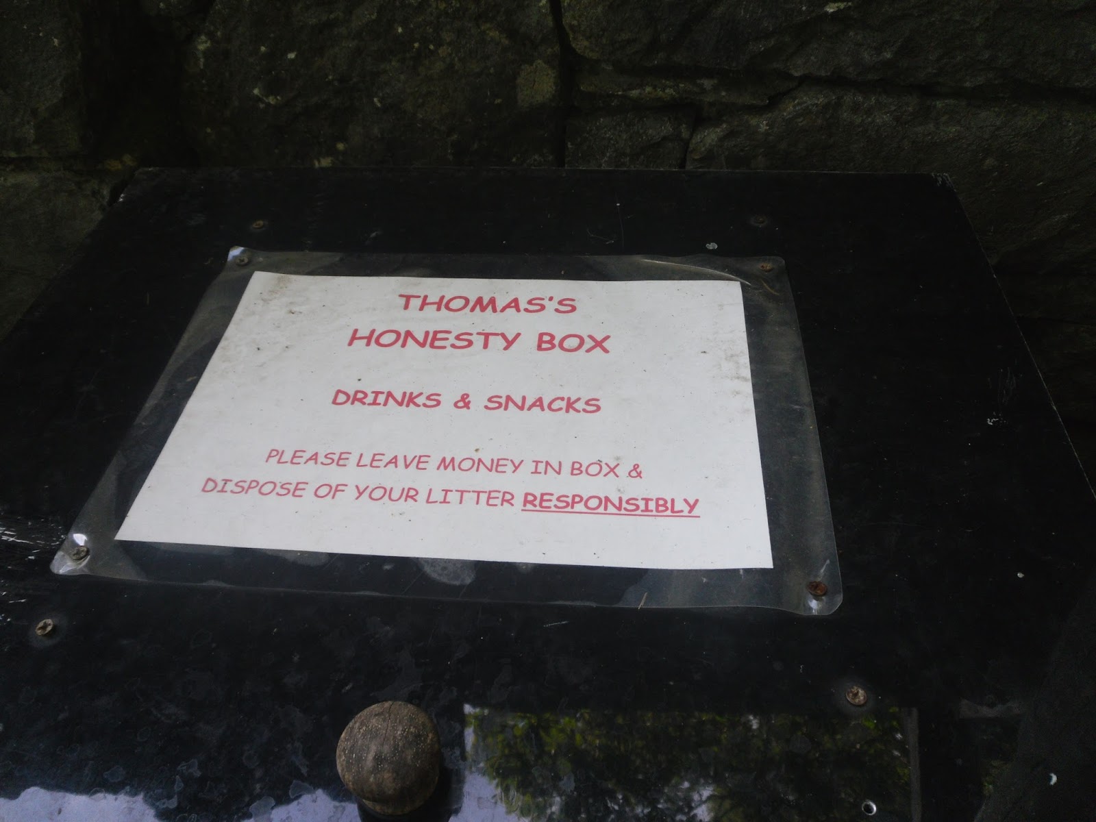 |
| 'Honesty Box' |
 |
| WATER AND CHOCOLATE! |
I smile happily. Water! Mars Bars! I take both and leave £3.00, what a blessing after losing my water bottle just a few hours ago. I'm close to my final destination and I pull out my map:
 |
| The red 'X' marks where I crossed the river wrongly |
I still wasn't particularly good at gauging how long it took me to walk a certain distance. I convinced myself to pull off my boots and cross a river. The map is telling me to cross the river. There isn't anywhere else to go. I have to cross it!

 |
| Boots off and socks off... |
I lift my foot carefully and the moving water dislodges my flip-flop. Shit! I watch the water carry away my shoe and I stumble onto the bank. I needed that. I can't wear my boots all day and they were so good for campsite showers. That's x1 water bottle and x1 flip-flop lost in a day.
I climb up from the bank and emerge on a clearing of land. Sheep are grazing and I'm surrounded by a tall, stone wall. I'm boxed in without anywhere to go on private land. I feel utterly dejected and I have no choice but to cross back. I trudge back towards the country road in frustration. I don't know where to go! I followed the map! It's early evening and I am lingering, unsure of my next move.
I stop walking and I suddenly feel overcome by feelings of self-frustration. My inability to accurately read maps. My impulsivity that adds countless miles to each day. I unclip my cross-chest strap. The rucksack has been digging painfully on the same spot for far too long.
I hear a rumble and a 4x4 car swerves round the corner. I give a half-heartened wave with my map in hand. The car slows and a lady rolls down the blackened windows.
- "Are you ok?" she asks.
- "I'm really sorry I'm lost, can you tell me how to get to Shap?"
- "Turn left at this road and keep following it"
- "Thank you so much!"
- "Do you want a lift? Are you alone? You look exhausted."
I feel dead on my feet and my heart swells with relief at the prospect of a lift. Her husband opens the boot where I drop my bag in and I climb in the back, sitting next to her two kids.
- "So you're doing the coast to coast alone?!"
- "Yeah, it's quite hard to find friends who want to walk 200 miles with me" I reply lightheartedly.
They chuckle at my statement. In truth, I didn't ask anyone to do the walk with me. I booked the train tickets impulsively, without consulting my friends or family firsthand. Ten minutes later, The family drop me off in Shap next to my accommodation, New Ing Lodge. I thank them over and over. It is 8:00pm and I am utterly grateful for not having to walk in the dark.
I'm ready for bed. It's a cold night and I quickly set up my tent, dropping my rucksack inside. There is a glow from the building and I decide to explore it, in hope that there is a lounge area. My tent is just about tall enough to accommodate me sitting cross-legged in the centre. Better a nice warm building then my small, green alcove I think.


There is a cosy, warm seating area with squishy armchairs, occupied by around seven guests. The fire casts a yellow, homely glow across the room and the lodge owner is telling everyone anecdotes of walkers who get into trouble and call mountain rescue. I discreetly squeeze into the group and meet six other walkers, 4 Americans and 2 Brits, also doing the coast to coast.
Day 5 - Plain Sailing Day
(Shap to Olton)
I pack my tent up simultaneously with two others , Hannah and Adam, who were also camping and doing the c2c. They were supporting large rucksacks. Yay, it's not just me holding all my gear! The majority of c2c walkers use baggage transportation services such as 'Sherpa-van' and 'Pack-horse' in order to transport luggage from one accommodation to the next for the length of the walk. It was refreshing to finally encounter other backpackers.

We leave together for Olton, walking and talking. The bonds build quickly and time flies, Adam is a excellent navigator. Where I stand, ponder and try to establish the correct route, Adam is able to glance at the map, his surroundings and decide upon the right direction expertly.
I take in my surroundings. I would've never been able to navigate this. It was an expanse of endless fields. Sometimes there were tell-tale signs of walkers passing by such as flattened grass or muddy bootprints. Or there was the occasional c2c sign. The coast to coast is a very popular walk, but for this leg it was like trying to follow a faint bread-crumb trail in vast and extensive fields.
 |
| Fields with no significant landmarks for navigation... |


We arrive at Olton by lunch-time and I set up my tent alongside Hannah and Adam, in the garden of Victoria Hotel for £5.00. The landlady collects the fee, and shows us the bathroom. Wow!! The bathroom is beautifully tiled and fully stocked with bubble bath, shower gel and shampoo. It was luxurious compared to the buggy, outside campsite showers I grew accustom to.
After setting up, Adam, Hannah and I order a Sunday roast. We are presented with plates generously portioned with slices of soft, tender beef, crisp and fluffy potatoes and vegetables all encompassed in a large yorkshire pudding baked to perfection and topped with gravy. I devour every last bite. Walking with a rucksack creates a big appetite.
We spend the afternoon relaxing in the bar. I run a bath and fill it with bubbles, a fruity scent emanates and the warm water envelopes, cushions and soaks my muscles. I close my eyes and sigh. God, I needed this. This is it. Beautiful views, beautiful food and a relaxing afternoon after walking. This is what the coast to coast walk is!
We close the evening socialising with other Australian and American c2cers. Pauline, a Australian walker, buys us sticky toffee pudding and a mixed berry crumble. "I'm treating you guys, I know what its like being a backpacker".
I'm happy to have met such wonderful company. The opportunity to soak in a bath. A delicious lunch. My coast to coast was finally falling into motion.
Day 6 - Restock Day
(Olton to Kirby Stephen)
For the first time, I decide to buy breakfast before I walked (I normally snack on breakfast biscuits or cereal bars along the way) . I'm sick of being hungry when I walk, it just makes things harder. For £5.00, I munched through a breakfast banquet, eating a full English breakfast with toast washed down with orange juice and tea. I'm stuffed, but I discreetly steal a apple for the walk.
I converse with Pauline and Katherine from Australia. They describe the vastness of Australia, where one can drive for hundreds of miles and not encounter a single soul. Katherine describes the starscape. A black expanse with a plethora of bright, glowing, moving stars and no light pollution. "If you lie down and stare at the sky long enough, your eyes adjust. You see even deeper into the galaxy and even more stars then you ever thought imaginable." I feel my inner-stirrings of wanderlust. Australia: one day. Before I go, Katherine hands me her card. "If you are ever in Australia and need a place to stay, feel free to contact me". I thank her for her kind gesture and begin the hike to Kirkby Stephen (a town) with Hannah and Adam.
 |
| Day 6: 82 miles in! |
I limp a little. My feet have finally succumb to blisters: 2 on my heels and 1 beneath my toes. I also feel slow and sluggish as a result of the big breakfast. I see the irony in the situation: the food hasn't energised me, it's slowed me down!
We reach Kirkby Stephen in the early afternoon and we set up our tents in a caravan park. We spend the evening exploring the town. Luckily, I come across a bookshop with Henry Stedman's Coast to Coast guidebook. I buy it immediately. I've seen nearly every c2cer using it and the map alone wasn't sufficient enough for my poor navigation skills.
 |
| Kirkby Stephen |
I retire to bed early that night as my feet were throbbing in protest/pain.
Day 7 - Knee Deep in Mud Day
(Kirkby Stephen to Keld)
It is a very steep uphill ascent from Kirkby Stephen, as we begin our walk up to Nine Standards Rigg at 662M. Today marks our halfway point of the coast to coast walk, 100 miles to go. All the rivers now flow to 'The North Sea' to the East as opposed to 'The Irish Sea' to the West.
 |
| 9 Standards Rigg |
The walk was extremely wet, muddy and boggy. We attempt to side-step, jump and dodge the worse of it.


The 9 Standards Rigg is a endless, wild field of ankle-twisting, trip inducing hard clumps of grass. We hike around bogs and through the grassland, occasionally sinking with each step we take. I reach a light green, soft, mossy area. Surely this will take my weight. 1, 2, 3 light quick steps and you will be over. I brace myself, pulling my rucksack close to my back and attempt to step lightly onto the balls of my feet.
My heart drops to the floor. Upon taking my first step, my leg sinks straight through the moss, like water falling through a trapped door. I'm up to my lower thigh in bog. The mud clings instantaneously to my leg with a cement like grip. I push and strain relentlessly against the floor, attempting to free my leg which feels set and unyielding. Hannah grabs my hand. After a few very hard yanks, we manage to free my leg, which is now completely covered in wet mud. Well, look on the bright side I thought. At least your boot didn't come off with the pulling and at least you're not alone. We walk on, my socks are completely sodden and I have a boot full of bog.


The weather begins to clear as we get closer to Keld. We pass a waterfall and we camp alongside a river at Park Lodge campsite, in the Yorkshire Dales.


Fun Facts/Week 1 Round-up
- The first half of the Coast to Coast walk complete! (over 90 miles: 28th August >> 4th September).
- I budgeted on £15.00 a day and I stuck to this completely for my first walking week. I'd spent a total of £100.30 including camping fees and pub meals.
- Accommodation cost for the week: £40.25
- I'd met more Canadians/Americans then I have British people doing the walk (only 2 Brits!)
- Nights at: 1 good samaritan's sofa, 1 400m wild mountain camp, 1 Youth hostel, 2 campsites, 1 hotel garden and 1 caravan park.
- It took around 4 days for me to get used to walking with the weight of my pack (13 - 15kg).
- I've been quite lucky with the weather, I hadn't been rained on yet other then the odd, 5 minute of light scattering rain.
- Got lost 5 - 10 times, but what better way to learn to map read then be out there on the field doing it :).
- Flip-flops and a red water bottle lost.
- Learning curves: A rucksack makes you walk a lot slower. I now carry 2L of water with me instead of 1L. Eat little amounts regularly to keep your energy levels up. Walking with wet socks is the worse, most grimey feeling ever. You can only get good at map-reading with lots of practise.
- Anwar, if you read this, Thank-You. You're my hero and your actions on Day 1 helped to restore my faith in humanity.
- My train fare from London Euston to St Bees was £29.35. Book way in advance to get cheap prices.
- On Day 2, I got lost near Black Sail Hut. This area is notorious for serious navigational errors. Please see the notes at: http://www.wainwright.org.uk/coasttocoast.html to avoid making the mistakes that I made.
- To read part 2 of my coast to coast walk, go to: http://days-of-adventure.blogspot.co.uk/2013/09/my-coast-to-coast-walk-week-2.html

Great work Thidarat, I'm amazed you carried on after those first few days! Jeremy
ReplyDelete